

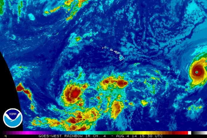
Região central do Pacífico, região do El Niño
05.08.2014 Furacão Iselle
Ventos de 200 km/h e deslocamento no sentido oeste a 4 km/h EM DIREÇÃO AO HAWAI.
04.08.2014 Furacão Iselle
Ventos de 224 km/h e deslocamento no sentido oeste a 6 km/h EM DIREÇÃO AO HAWAI.
03.08.2014 Furacão Iselle
Ventos de 184 km/h e deslocamento no sentido oeste a 7 km/h EM DIREÇÃO AO HAWAI.
hawaiinewsnow.com
HONOLULU (HawaiiNewsNow) - Hurricane Iselle has regained intensity and is once again a major hurricane with maximum sustained winds of 140 miles per hour, making it a strong Category 4 hurricane.
At 5 a.m. Monday, it was located about 1,257 miles east of Hilo and was moving west at 9 miles per hour. It is expected to move into the Central Pacific on Tuesday. Little change in strength is expected overnight, with slow weakening beginning Tuesday.
The latest forecast cone from the National Hurricane Center brings Iselle as a tropical storm over or near the Big Island as soon as Thursday evening. Longer-range models bring Iselle, maintaining tropical storm strength over the smaller islands Friday.
The National Hurricane Center expects a faster weakening trend after 48 hours as the storm encounters increasing shear and decreasing sea surface temperatures, but the forecast models still keep Iselle strong enough to maintain tropical storm strength five days from now.
Hurricane Iselle Moving West in the Eastern Pacific
Published: Aug 2, 2014, 11:47 AM EDT
weather.com
Iselle bypassed the tropical depression status and formed as a
tropical storm in the eastern Pacific ocean about 1075 miles southwest
of the tip of Baja California on Thursday, July 31.Iselle gained strength as it moved west-northwest through open waters and became a hurricane on August 1. This makes Iselle the fourth hurricane of the 2014 eastern Pacific hurricane season.
Thankfully, Iselle will remain far from land over the next five days. Iselle should begin to weaken early next week as it moves into more stable air less conducive for maintaining thunderstorms and over cooler water.
Iselle does not pose an immediate threat to the Hawaiian Islands. Most tropical cyclones approaching Hawaii from the east weaken substantially before they approach the Big Island, which is consistent with the current forecast of Iselle. If there's anything left of the circulation, it may approach the longitude of the islands late next week.

Projected Path
Projected Path
The latest forecast path and wind speeds from the National Hurricane Center.
Storm Information
Current Information
So, where exactly is the cyclone's center located now? If you're plotting the storm along with us, the information depicted in the map above provides the latitude/longitude coordinates, distance away from the nearest land location, maximum sustained winds and central pressure (measured in millibars).
Infrared Satellite
Infrared Satellite
This infrared satellite image shows how cold (and therefore how high) the cloud tops are. Brighter orange and red shadings concentrated near the center of circulation signify a healthy tropical cyclone.FURACÃO BERTHA VOLTA A SER TEMPESTADE TROPICAL NO ATLÂNTICO NORTE
NA COSTA LESTE DOS ESTADOS UNIDOS
Abaixo Furacão Bertha em 04.08.2014

05.08.2014 Tempestade Tropical Bertha
Ventos de 104 km/h e deslocamento no sentido north-norteast a 13 km/h.
04.08.2014 Furacão Bertha
Ventos de 128 km/h e deslocamento no sentido norte a 10 km/h.
04/08/2014 13h56 - Atualizado em 04/08/2014 13h56
Tempestade tropical Bertha vira furacão
Fenômeno se encontra ao norte da costa das Bahamas.
Furacão não deve tocar em terra nos EUA.
A tempestade tropical Bertha ganhou força nesta segunda-feira (2) e se
transformou no segundo furacão da temporada a afastar-se das Bahamas,
informaram os meteorologistas americanos.
O fenômeno não deve tocar em terra na costa leste dos Estados Unidos.
O Centro Nacional de Furacões (NHC) informou que o centro da tempestade se encontrava 370 km a nordeste da ilha Grande Ábaco, norte das Bahamas.
A tempestade se dirigia para o norte, a 28km/h, com ventos de até 130 km/h e rajadas mais fortes.
Por outro lado, o furacão Iselle, no Pacífico, se dirigia para o Havaí, mas o fenômeno deve perder intensidade nos próximos dias, segundo o NHC.
Iselle, de categoria três na na escala Saffir-Simpson de cinco, estava 2.100 km a leste de Hilo, no Havaí, e avançava a 15 km/h com ventos de até 205 km.
Por sua trajetória, se prevê que Iselle passe na noite de quinta-feira ao norte da ilha Oahu, a ilha mais povoada do Havaí, apesar de enfraquecido.
Além disso, a tempestade tropical Júlio se formou no Pacífico e seguia os passos de Iselle.
Nenhum comentário:
Postar um comentário