

Imagem pelo Radar Doppler do dia 11.11.2014 mostra em azul, muita neve no norte dos Estado Unidos. Essa é mais uma consequência do Fenômeno El Niño, que causa maior evaporação e portanto mais chuvas em mais neve.
Tormenta de Nieve Azota 43 Estados En Estados Unidos [MAPAS]
First Posted: Nov 11, 2014 01:41 PM EST

Heavy snow forecast across parts of north-central U.S. (Photo : NOAA)
Los
habitantes de los estados del centro-occidente de Estados Unidos fueron
sorprendidos por una ola de aire frio acompañado de bajas temperaturas y
repentinas tormentas de nieve, pronosticando temperaturas gélidas para
los próximos días.
Like Us on Facebook
De acuerdo al Sistema Meteorológico Nacional, el sistema de alta presión de aire frio se moverá hacia el norte-noreste causando tormentas moderadas de nieveLos estados más afectados por las tormentas de nieve son Minnesota, Wisconsin y Michigan, Montana, Wyoming y las Dakotas; en donde se espera un descenso de temperatura a hasta 20 grados centígrados por debajo de su nivel normal.
De acuerdo a El Nuevo Herald, algunas escuelas cancelaron clases desde los estados de Minnesota hasta Dakota del Sur debido a las bajas temperaturas y las nevadas. Los conductores de las carreteras en Wisconsin extremaron precauciones al encontrarse con un asfalto congelado y resbaladizo por el hielo.
El sistema de alta presión mantiene dirección al Este del país y se espera que en los próximos días se registren bajas temperaturas y corrientes de aire frio en los estados de la costa este.
La ola de aire frío por el centro-occidente de Estados Unidos de sebe a una enorme tormenta que acarreó aire ártico desde las islas Aleutianas de Alaska con vientos similares a los de un huracán.
El meteoro superó la intensidad de la supertormenta Sandy que azotó la costa Este de Estados Unidos en 2012, causando la muerte de 182 personas y daños superiores a los 65,000 millones de dólares.

(Photo : NOAA)
Heavy snow forecast across parts of north-central U.S.
Heavy snow forecast across parts of north-central U.S.

(Photo : NOAA)
Heavy snow forecast across parts of north-central U.S.
Heavy snow forecast across parts of north-central U.S.

(Photo : NOAA)
Heavy snow forecast across parts of north-central U.S.
Heavy snow forecast across parts of north-central U.S.

(Photo : NOAA)
Heavy snow forecast across parts of north-central U.S.
Heavy snow forecast across parts of north-central U.S.
Round two of storm brings more snow to state
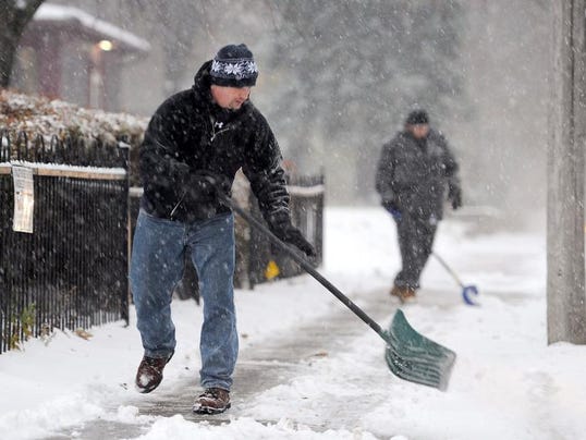
PIERRE, S.D. — After being buried under more than a foot of snow,
parts of the Rockies and Upper Midwest were getting their first icy
touch of arctic air on Tuesday. And the rest of the Midwest and the East
are expecting a dose later in the week, with temperatures forecast as
much as 40 degrees below average.
The frigid air was pushed in by a powerful storm that hit Alaska with hurricane-force winds over the weekend.
A look at the storm and its effects:
ISN'T IT STILL FALL?
Winter is still more than a month away, but it doesn't feel like it.
Residents were digging out from as much as 13 inches of snow Tuesday morning in northern Wisconsin, where several school districts cancelled classes, while some Minnesotans awoke to 15 inches of fresh powder — with more snow expected.
Michigan's Upper Peninsula also was buried under at least a foot of snow Tuesday — with another foot or two expected before the storm passes. National Weather Service meteorologist Justin Titus said roads are in "very poor condition," with 2 to 3 inches of snow falling an hour on Tuesday morning.
Terri Sommerfeld, a clerk at Ace Hardware in Webster, Wisconsin, said the store usually sells six or seven snowblowers in a typical winter. That's how many the store has sold in two days.
"It hasn't been overly busy today, but the ones that are coming are buying snowblowers and shovels," she said.
THE COLD AFTER THE SNOW
The blast of frigid weather sent temperatures tumbling in the Texas Panhandle, plunging from the 70s into the teens. Similar balmy weather in Missouri was replaced by temperatures in the 20s — dropping some 40 degrees overnight — along with a light dusting of snow.
In parts of Colorado, temperatures fell into the teens — about 20 to 30 degrees below normal — and they're expected to remain through Thursday.
SNOW: NO JOKE FOR FARMERS, BUT RANCHERS CAN BEAR IT
The storm stirred anxiety for some farmers in Minnesota and South Dakota whose corn had not yet been harvested. The corn can withstand the cold, but deep snow may delay farmers getting it out of fields.
Yet ranchers in the Dakotas were surprisingly upbeat with only a few inches of snow in the forecast, after intense storms in October 2013 killed at least 43,000 cattle that hadn't yet developed their heavy protective winter coats.
This year, "we've had enough cool weather that they're haired up like bears," said South Dakota Stockgrowers Association President Bob Fortune, who ranches near Belvidere, South Dakota. "They can take winter now."
READY. SET. WAIT.
Minneapolis-St. Paul International Airport saw the brunt of the cancellations and delays Monday, with 150 cancellations, while about 19 flights had been cancelled Tuesday out of hundreds of arriving and departing planes, according to the airport. There were no delays Tuesday morning at Sawyer International Airport in Michigan's Upper Peninsula.
KEEP CALM AND SHOVEL ON
The snow got a mixed reception in Minneapolis, where the first inch tripled morning drive times Monday. At one point, the weather turned to sleet, and tiny pellets stung uncovered faces and hands. Crews were plowing, shoveling or brushing off sidewalks, and snowplows did several loops around city streets.
Richard Anderson, who was decorating small trees outside Seven Steakhouse, was downcast.
"As a professional holiday decorator you'd think I'd appreciate it. But I appreciate it when I'm all finished, and I'm finally sitting down and enjoying my own Christmas tree," Anderson said. "It's wet, cold, sticks to you. It's freezing on your jacket as it's raining. What do you call it? Rain, sleet and snow. And it's bitter. It's really bitter. It's not very nice."
Elsewhere, in Minnesota, the State Patrol said at least two people were killed in accidents on icy roads and troopers handled 475 crashes and more than 700 spinouts statewide by Monday evening.
In eastern Wisconsin, snow-covered roads were blamed for a school bus crash that sent the driver and an aide to a hospital, WBAY-TV reported.
In Chicago, some people were savoring breezy but mild weather near 60 before unseasonably cold freezing temperatures arrive Wednesday.
"I just wanted to enjoy one of the last nice days," said 44-year-old Joe Kauda, of the Chicago suburb of Carol Stream.
Mapa das temperaturas do dia 12.11.2014, mostra que na Sibéria já chega a - 30°C:

expresso.sapo.pt/
Primeira neve de outono já fecha estradas na Serra da Estrela

Segundo o CDOS, os troços Piornos/Cruzamento da Torre (troço 11), Cruzamento da Torre/Torre (12) e Lagoa Comprida/Cruzamento da Torre (13) foram encerrados cerca das 5h de hoje. Mais tarde, cerca das 8h30 e ainda devido à queda de neve, foram fechados à circulação rodoviária os troços Portela do Arão/Lagoa Comprida (troço 01) e Lagoa Comprida/Sabugueiro (troço 02).
Fonte do Centro de Limpeza de Neve da Estradas de Portugal diz que pelas 9h continuava a nevar e na área das suas instalações, nos Piornos, os termómetros marcavam um grau negativo.
A primeira neve do outono, que começou a cair pelas 4h30, "é pouca coisa", referiu a fonte, embora suficiente para fechar as estradas do ponto mais alto da Serra da Estrela. "Se continuar a nevar, será difícil reabrir as estradas", disse, não adiantando previsões para a reabertura dos troços encerrados à circulação automóvel.
Em relação ao último ano, este primeiro nevão surge mais cedo, pois em 2013 as primeiras neves aconteceram a 16 de novembro.
Ler mais: http://expresso.sapo.pt/primeira-neve-de-outono-ja-fecha-estradas-na-serra-da-estrela=f896531#ixzz3IsjpwLl3
Nenhum comentário:
Postar um comentário