

11.04.2014 Ciclone Tropical Ita, com ventos de 201 km/h e deslocamento no sentido sul a 5 km/h no nordeste da Austrália.
10.04.2014 Ciclone Tropical Ita
Ventos de 185 km/h e deslocamento no sentido sudoeste a 5 km/h NORDESTE DA AUSTRÁLIA.

Cyclone Ita expected to make landfall on Friday night near Cooktown
Weather bureau says cyclone has been downgraded to category four storm but winds of up to 275 km/h could be expected
Tropical Cyclone Ita was due to make landfall in Queensland on
Friday night near Cooktown but was downgraded to a category four storm.
The weather bureau said the cyclone had slowed but winds of up to 275 km/h could be expected when the cyclone hit land north of the Daintree region, between 9pm and midnight.
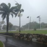
More than 9,000 residents of far north Queensland coastal communities in the path of the tropical cyclone were warned to expect “very destructive winds”, possible flash flooding and storm surges as the giant weather system bears down.
The main evacuation centre in Cooktown was locked down with around 300 people inside, the ABC reported. There are also reports of power outages.
30,000 residents in Cairns were urged to evacuate.
The Queensland premier, Campbell Newman, said that despite the downgrading, Ita remained a "very destructive cyclone which has very strong winds”.
"The communities of Hope Vale and Cooktown are staring down quite a destructive cyclonic event,” Campbell said. “Those communities, by now, should have seen people moved to cyclone shelters or taking refuge in more modern buildings."
He warned that buildings built before 1985 could be at risk.
"Remember the safest part of the building is usually in the bathroom because of the plumbing and strengthening of the walls in that part of the structure," he said.
He said that further emergency services would be deployed to affected regions as soon as it was safe to do so.
He said that once the cyclone passed the priority would be to restore vital services including electricity, which he warned could be "down for some time".
CLIMATEMPO
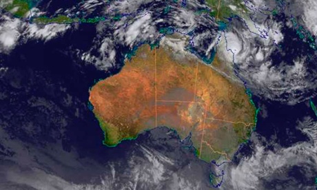
O Ciclone Tropical Ita alcançou a costa Australiana entre ontem e hoje. São previstas rajadas de vento de até 170 km/h no nordeste do país segundo as informações do serviço de meteorologia da Austrália (www.bom.gov.au).

Esse ciclone chegou a ser classificado como categoria 5 na escala Saffir-Simpson nos últimos dois dias, com rajadas de vento de até 230 km/h. Ao atingir a costa passou a categoria 3 com ventos de até 170 km/h.
Esse sistema começou como um sistema de baixa pressão na sexta-feira passada próxima das Ilhas Salomão e se deslocou para oeste no decorrer da semana, atingindo categoria 5 na quinta-feira próximo a costa da Austrália.
O mar também está muito agitado, com previsão de ondas de até 5 metros na costa e de aproximadamente 6 metros no mar.

The weather bureau said the cyclone had slowed but winds of up to 275 km/h could be expected when the cyclone hit land north of the Daintree region, between 9pm and midnight.
More than 9,000 residents of far north Queensland coastal communities in the path of the tropical cyclone were warned to expect “very destructive winds”, possible flash flooding and storm surges as the giant weather system bears down.
The main evacuation centre in Cooktown was locked down with around 300 people inside, the ABC reported. There are also reports of power outages.
30,000 residents in Cairns were urged to evacuate.
The Queensland premier, Campbell Newman, said that despite the downgrading, Ita remained a "very destructive cyclone which has very strong winds”.
"The communities of Hope Vale and Cooktown are staring down quite a destructive cyclonic event,” Campbell said. “Those communities, by now, should have seen people moved to cyclone shelters or taking refuge in more modern buildings."
He warned that buildings built before 1985 could be at risk.
"Remember the safest part of the building is usually in the bathroom because of the plumbing and strengthening of the walls in that part of the structure," he said.
He said that further emergency services would be deployed to affected regions as soon as it was safe to do so.
He said that once the cyclone passed the priority would be to restore vital services including electricity, which he warned could be "down for some time".
CLIMATEMPO
Ciclone Tropical Ita chega à costa australiana
11 de abril de 2014 às 14:03 por Bianca Lobo
O Ciclone Tropical Ita alcançou a costa Australiana entre ontem e hoje. São previstas rajadas de vento de até 170 km/h no nordeste do país segundo as informações do serviço de meteorologia da Austrália (www.bom.gov.au).
Esse ciclone chegou a ser classificado como categoria 5 na escala Saffir-Simpson nos últimos dois dias, com rajadas de vento de até 230 km/h. Ao atingir a costa passou a categoria 3 com ventos de até 170 km/h.
Esse sistema começou como um sistema de baixa pressão na sexta-feira passada próxima das Ilhas Salomão e se deslocou para oeste no decorrer da semana, atingindo categoria 5 na quinta-feira próximo a costa da Austrália.

O mar também está muito agitado, com previsão de ondas de até 5 metros na costa e de aproximadamente 6 metros no mar.
Previsão da altura de ondas
washingtonpost.com
Beastly category 5 tropical cyclone Ita threatens northern Australia

Severe tropical cyclone ITA (NOAA)
The storm is classified as a severe category 5 tropical cyclone on Australia’s 1-5 scale. This scale is slightly different from the Saffir-Simpson wind scale used in the U.S. and has a lower threshold for category 5. But Ita’s 185 mph gusts, and sustained winds of nearly 150 mph (according to the forecast of the Joint Typhoon Warning Center) would make it the equivalent of a major category 4 storm in the U.S.

Projected track of tropical cyclone Ita (Australia Bureau of Meteorology)
Ita will likely produce a large storm surge north of Cairns, with the highest levels likely north of Cape Flattery. Interestingly, the peak surge will likely be located just south of the location of Severe Tropical Cyclone Mahina’s massive storm surge in 1899. Although scientific sources disagree about the details of Mahina’s surge, many sources indicate that Mahina generated a 13.7-m (45 ft) storm tide near Bathurst Bay, Queensland. This water level ties Mahina with a Bangladesh surge in 1876 for the highest credible storm surge observation in the scientific literature. In short, Severe Tropical Cyclone Ita will likely produce a massive storm surge near the world’s highest (tied for highest) historical storm surge site.(Needham notes that Ita with a central pressure of 934 mb is not quite as strong as Mahina at 915 mb, and probably won’t generate as large a surge).
A silver lining is that Ita’s projected landfall zone is not heavily populated.
“Ita is expected to hit the coast in a sparsely populated area. Only 9000 people live in the 200km stretch between Cape Melville and Cape Tribulation,” writes the Australian.
The Australia Bureau of Meteorology is urging those in the storm’s path to prepare:
Coastal residents between Cape Melville and Cape Tribulation including Cooktown are specifically warned of the dangerous storm tide as the cyclone crosses the coast later today. The sea is likely to rise steadily up to a level which will be significantly above the normal tide, with damaging waves, strong currents and flooding of low-lying areas extending some way inland.The Weather Channel correctly points out: “The severity of the impacts in any one location will be dictated by exactly where the center of Ita tracks, which remains somewhat uncertain.”
According to the Australian, officials are concerned that if the storm shifts south towards Cairns (population of 150,000), more people are vulnerable.
Some of the storms outer bands are already swirling inland. You can track the storm on these radars:
Cairns | Willis Island
Tropical cyclones on the north coast of Australia are fairly common from November to April.
“On average 4.7 tropical cyclones per year affect the Queensland Tropical Cyclone Warning Centre Area of Responsibility,” notes the Australia Bureau of Meteorology.


Preparativi arrivo ciclone Ita, Port Douglas, Australia (Getty images)
BBC
NEWS ÁSIA
10 April 2014 Last updated at 12:46 GMT
Cyclone Ita: Queensland braces for category five storm

Forecaster Darren Betts: Ita "will bring destructive winds and flooding"
The
Australian state of Queensland is bracing for the arrival of Cyclone
Ita, a category five storm set to hit its far north coast.
The storm is expected to hit the Cape York peninsula late on Friday night, bringing very destructive winds. It was expected to bring damaging waves to some low-lying areas, the Bureau of Meteorology (BOM) said, and heavy rain could cause flooding.
It is the strongest storm to hit since Cyclone Yasi, which struck in 2011.
Cyclone Ita was expected to make landfall between Cape Melville and Cape Tribulation "as a severe category five tropical cyclone with very destructive winds near the core and gales extending some distance from the landfall", the BOM said.

Gales could extend 190km (118 miles) out from the centre of the storm, it said, potentially affecting several towns including Port Douglas, a popular tourist hub north of Cairns.
Queensland Premier Campbell Newman urged people to be ready for the storm.
"The big concerns people need to prepare for are a storm surge, which means in low-lying areas water much higher potentially than normal tides," he said.
 Cyclone Ita has already caused flash floods in the Solomon Islands
Cyclone Ita brought torrential rain to the Solomon Islands late last week, causing flash floods that left at least 21 people dead.
Are you in Queensland? Are you making preparations for Cyclone Ita? If you would be happy to speak with the BBC please email haveyoursay@bbc.co.uk using subject Cyclone Ita.
Nenhum comentário:
Postar um comentário