

Imagem animada do Tufão Rammasun em 17.07.2014 categoria 4
Aqui imagem visível do Tufão Rammasun em 16.07.2014

Aqui o Tufão Rammasun pelo Google Earth em 16.07.2014 no mar da China Meridional.

18.07.2014 Tufão Rammasun
Ventos de 217 km/h e deslocamento no sentido oeste-noroeste a 7 km/h CATEGORIA 4 NO SUL DA CHINA.
17.07.2014 Tufão Rammasun
Ventos de 193 km/h e deslocamento no sentido noroeste a 8 km/h CATEGORIA 4 NO SUL DA CHINA.
17.07.2014 Tufão Rammasun
Ventos de 152 km/h e deslocamento no sentido noroeste a 6 km/h CATEGORIA 2 em direção ao sul da CHINA.
16.07.2014 Tufão Rammasun, com ventos de 128 km/h e deslocamento no sentido oeste-noroeste a 9 km/h, pressão atmosférica de 955hPa, CATEGORIA 1 EM DIREÇÃO AO SUL DA CHINA.
15.07.2014 Tufão Rammasun, com ventos de 160 km/h e deslocamento no sentido oeste a 5 km/h, pressão atmosférica de 970hPa, CATEGORIA 3 no NORTE DAS FILIPINAS.
14.07.2014 Tufão Rammasun, com ventos de 104 km/h e deslocamento no sentido oeste-sudoeste a 10 km/h CATEGORIA 1 NO NORTE DAS FILIPINAS.
.
12.07.2014Tempestade Tropical Rammasun, com ventos de 56 km/h e deslocamento no sentido oeste a 12 km/h EM DIREÇÃO ÀS FILIPINAS.
TERÇA-FEIRA TORNA-SE TUFÃO CATEGORIA 1.
TERRA NOTÍCIAS
Após passar pelas Filipinas, Tufão Rammasun atinge a China
Fenômeno chegou à ilha de Hainan com ventos de até 216 km/h
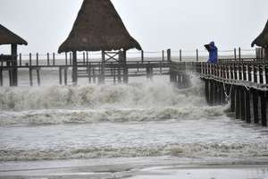
Homem filma fortes ondas no sul da província de Hainan, na China, enquanto o tufão Rammasun se aproxima do local
Foto: AFP
")
A China foi atingida nesta sexta-feira pelo tufão Rammasun, o mais forte a afetar o país em 40 anos. O fenômeno já tinha provocado 54 mortes nas Filipinas.
Rammasun (Deus do trono, em tailandês) chegou na
sexta-feira à tarde (no horário local) com ventos de até 216 km/h na
costa da ilha tropical de Hainan, segundo a imprensa local.
O tufão provocou uma morte na cidade de Wenchang, em Hainan, segundo a agência de notícias Xinhua.
accuweather.com
Typhoon Rammasun, Packing 140 mph Winds, Nears Hainan

By Eric Leister, Meteorologist
July 17, 2014; 8:20 PM
Rammasun now packs winds of 140 mph with higher gusts. The eyewall is now well established, so further strengthening is possible in the last few hours before landfall.
Rammasun is expected to make landfall as the equivalent of a Category 4 hurricane within the next six hours.

Damaging winds will also be possible across southern Guangdong and Guangxi Provinces later Friday into Friday night in China as well as northern Vietnam late Friday night into Saturday.
Flooding rain, mudslides and coastal storm surge will also be risks associated with Rammasun.

A devastating storm surge will be possible in northern and eastern Hainan Island as well as the southwest coast of Guangdong, including the Leizhou Peninsula.
Rainfall of 100-200 mm (4-8 inches) is expected from Hainan Island through southern parts of Guangdong and Guangxi Province and across northern Vietnam, including Hanoi with local amounts around 300 mm (12 inches)
 Satellite image of Typhoon Rammasun on Thursday, courtesy of NOAA.
Hong Kong will remain far enough to the north, that any impacts will be limited to higher surf and a few downpours and gusty winds as the outer bands of the storm pass through the area.
Due to the rugged terrain of northern Vietnam, Rammasun will quickly weaken as it moves inland and become a post-tropical low by Sunday.
scmp.com/news/hong-kong
T3 signal raised as Typhoon Rammasun brings strong winds and rain to Hong Kong
Squally showers and gusts of wind up to 70km/h expected as Typhoon Rammasun edges towards the coast of western Guangdong
PUBLISHED : Wednesday, 16 July, 2014, 9:56am
UPDATED : Thursday, 17 July, 2014, 9:45pm

Dark clouds loom over Victoria Harbour as Typhoon Rammasun approaches Hong Kong. Photo: Felix Wong
At 9pm, Severe Typhoon Rammasun was estimated to be about 520 kilometres south of Hong Kong and is forecast to move northwest at about 22km/h in the general direction of western Guangdong and Hainan Island, the Observatory said.
 Rammasun was about 520km south of Hong Kong at 9pm. Photo: HKOOver
the past few hours, Rammasun continued to edge closer to southern China
and its rainbands are affecting the coast of Guangdong.
Rammasun was about 520km south of Hong Kong at 9pm. Photo: HKOOver
the past few hours, Rammasun continued to edge closer to southern China
and its rainbands are affecting the coast of Guangdong.Thundery showers on Thursday night brought more than 20 millimetres of rainfall to parts of the territory.
On the present forecast track, the chance of issuing higher signals tonight is not high, the Observatory said.
When Rammasun moves to the southwest of Hong Kong and edges close to the south China coast later on Thrusday and on Friday morning, local winds on high ground and over southwest coastal region will occasionally reach gale force.
Hong Kong awoke on Thursday morning to a No 1 signal issued by the Observatory as wet and windy weather on the fringes of the typhoon brought some respite to days of stiflingly hot weather that has seen the city swelter.
Watch: Typhoon shuts down Philippine capital
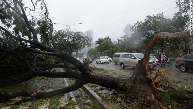
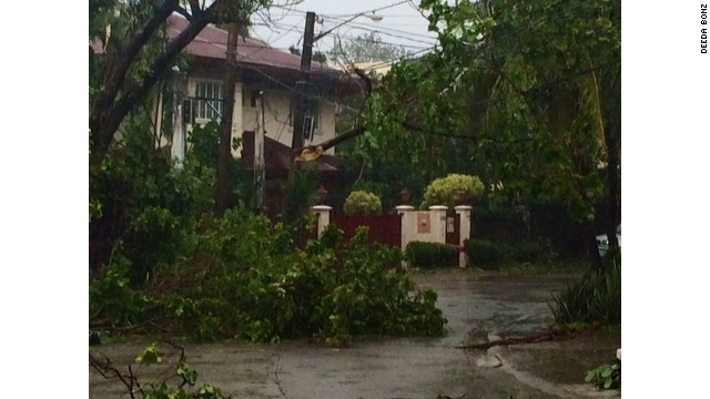
Typhoon Rammasun killed at least 11 people as it passed across the Philippines and hit the capital Manila on Wednesday, prompting the evacuation of more than 370,000 people, shutting financial markets, offices and schools.
The eye of the typhoon, the strongest storm to hit the country this year, passed to the south of Manila on Wednesday after cutting a path across the northern island of Luzon.
Cathay Pacific said it had cancelled four flights from Manila to Hong Kong on Wednesday and a further two from Hong Kong to Manila. The airline advised passengers to check their flight status on its website before departing for the airport.
Last week, Typhoon Neoguri battered Okinawa in Japan before moving to the Japanese mainland and forcing the evacuation of tens of thousands.
At least seven people were reported to have been killed as mudslides and floods hit houses.
While Hong Kong has avoided any typhoons so far this year, the city has sweltered, with the hottest June since records began in 1884.
The monthly average was 29 degrees Celsius – 1.1 degrees above normal for June.
em.com.br
Tufão Rammasun deixa 13 mortos nas Filipinas
AFP - Agence France-Presse
Publicação: 16/07/2014 07:37 Atualização: 16/07/2014 07:46

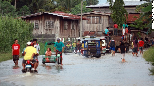
O primeiro tufão da temporada de chuvas nas Filipinas deixou pelo menos 13 mortos, obrigou a fuga de milhares de pessoas em todo o país e paralisou a capital, Manila. Com ventos de até 200 km/h, o tufão Rammasun arrancou telhados e árvores e provocou 13 mortes em todo o país.
O Rammasun, que em tailandês quer dizer "Deus do Trono", entrou na terça-feira à noite pelo Oceano Pacífico con ventos de 250 quilômetros e devastou pequenos vilarejos pesqueiros no leste das Filipinas. Depois perdeu um pouco de força e cruzou a ilha principal do arquipélago, Luzon.

O centro do tufão não passou por Manila, cidade de 12 milhões de habitantes, mas capital permanecia paralisada, como muitas áreas sem energia elétrica, incluindo o bairro de negócios Makati. Os ventos também provocaram destruição em bairros pobres perto da baía de Manila, onde milhares de pessoas vivem em condições precárias.
Quase 350.000 pessoas em todo o país foram obrigadas a deixar suas casas e seguir para centros de abrigo, segundo o governo. A cada ano, 20 tempestades em médias afetam as Filipinas, um arquipélago do sudeste asiático que é o ponto de entrada das tempestades que se formam nas águas quentes do Pacífico. Em novembro de 2013, o supertufão Haiyan devastou as ilhas filipinas de Samar e Leyte e matou 7.300 pessoas, em um dos maiores desastres naturais da história do país.
exame.abril.com.br
15/07/2014 09:48
Filipinas evacuam mais de 80 mil por chegada de tufão
O governo evacuou mais de 80 mil pessoas perante a chegada do tufão Rammasun, que tocará terra nesta terça

Meteorologistas observam tufão Rammasun: ventos podem chegar a 160 km/h
O tufão Rammasun, batizado com o nome de Glensa pelas autoridades locais, ameaça os filipinos em um momento em que os mesmos ainda se recuperam dos estragos causados pelo tufão Haiyan, que deixou 6,3 mil mortos e 28,7 mil feridos em novembro do ano passado.
"Por conta desta nova ameaça, o governo declarou alerta vermelho e intensificou os preparativos para reduzir ao máximo o número de vítimas nesta ocasião", disse hoje em comunicado o ministro de Comunicações, Herminio Coloma.
No nordeste do país, 17 províncias se encontram abaixo do nível de alerta 3, um abaixo do máximo, enquanto em Manila, que também poderia ser afetada pela cheia da maré, segue em nível 2.
Fontes da agência meteorológica das Filipinas (PAGASA) advertiram que o tufão Rammasun pode chegar a causar danos similares ao do tufão Xangsane, que em 2006 causou mais de 200 mortos e grandes destroços em Manila.
A temporada de tufões nas Filipinas, que geralmente vai de junho até novembro, registra entre 15 e 20 tufões todos os anos.
CLIMATEMPO
Tufão Rammasun segue para as Filipinas
14 de julho de 2014 às 09:45 por César Soares
Um
novo tufão se desenvolveu sobre o Pacífico Equatorial Oriental e segue
em direção às Filipinas. O sistema conhecido como Rammasun já tem
intensidade correspondente a categoria 1 de furacão da escala
Saffir-Simpson. A agência meteorológica japonesa (JMA – sigla em
inglês), já adverte para a intensidade dos ventos e da chuva.

Observação e previsão de rota da Tempestade Tropical Rammasun
No momento a tempestade se desloca para oeste
com uma velocidade de aproximadamente 30 km/h. Os ventos médios tem
intensidade de até 120 km/h e as rajadas máximas chegam aos 145 km/h. É
estimado que o centro de baixa pressão atmosférica tenha 975 hPa.
As regiões avermelhadas da imagem de satélite
indicam uma maior concentração de nuvens, nesta região há tempestades, o
amarelo indica um concentração menor de nuvens e com topos mais baixos,
a chuva tem intensidade moderada e as áreas azuis chuva fraca.

Imagem de satélite do infravermelho realçada fornecida pela NASA
Previsões indicam que o sistema ainda
pode ganhar mais força ao passar pelas Filipinas. Há o risco inclusive
de que ele chegue ao que corresponde a categoria 2 da escala
Saffir-Simpson ao se aproximar de Taiwan e de Hong Kong na China.
Não é a primeira vez que este nome é
utilizado para um tufão no Pacífico. No ano de 2002 e de 2008 outros
tufões também foram batizados com o mesmo nome.
accuweather.com
Typhoon Rammasun Targets the Philippines
 The above AccuWeather.com video details the weather across Asia.
Rammasun strengthened back to a tropical storm early on Sunday morning local time after briefly weakening to a tropical depression. This strengthening continued on Monday as Rammasun reached typhoon strength.
Rammasun first became a tropical storm on Friday afternoon; however, after bringing very little wind to Guam as it tracked near the island, the intensity was downgraded back to a tropical depression. Guam received 25 to 50 mm (1 to 2 inches) of rain on Friday from Rammasun which was the wettest day since May 25.
 Satellite image of Rammasun on Monday, courtesy of NOAA.
Rammasun has the potential to further intensify as it approaches the Philippines and makes landfall Tuesday night local time.
RELATED:
AccuWeather.com Western Pacific Typhoon Center
Philippines Weather Center
China Weather Center
Damaging winds and flooding rainfall is expected across the north-central and northern Philippines as Rammasun moves across the island nation late Tuesday into Wednesday.
Impacts from Rammasun are expected to begin in the eastern Philippines as early as Monday night, local time, as outer bands of rain begin to move onshore. Heavier rain and the greatest threat for flooding will not arrive until Tuesday, continuing through Tuesday night before winding down on Wednesday.
The greatest impacts are expected across northern Visayas and southern Luzon, close to the storm track. Heavy rain will total 100-200 mm (4-8 inches) along and near the track of the storm, including the cities of Naga and Manila where flooding will be a serious concern.

When crossing the Philippines, Rammasun is expected to weaken due to the interaction with land and will likely be a tropical storm as it emerges into the South China Sea. It will then move across the South China Sea and will begin to make a gradual turn to the northwest, towards the southern coast of China late in the week.
Moving over another area of very warm waters and low to moderate shear will give Rammasun the opportunity to regain typhoon strength before reaching China.
Late in the week Rammasun will then the threat for flooding rains and damaging winds to southern China with the greatest impacts likely in Hainan and western Guangdong provinces.
Continue to check back with the AccuWeather.com Hurricane Center for the latest on Rammasun and its effects in the Philippines and, eventually, into China.
Meteorologist Adam Douty contributed to this story.
Tropical Storm Rammasun Targets the Philippines
The above AccuWeather.com video details the weather across Asia.
Rammasun strengthened back to a tropical storm early on Sunday morning local time after briefly weakening to a tropical depression.
What was Tropical Depression 09W first became a tropical storm on Friday afternoon; however, after bringing very little wind to Guam as it tracked near the island, the intensity was downgraded back to a tropical depression. Guam received 25 to 50 mm (1 to 2 inches) of rain on Friday from Rammasun which was the wettest day since May 25.
Rammasun has maintained tropical storm intensity over the past two days while tracking to the west across the Philippine Sea.
TRACK
While Rammasun may gain some strength as it heads westward early this week, AccuWeather.com meteorologists feel that the storm will not become a typhoon before reaching the Philippines.
RELATED:
AccuWeather.com Western Pacific Typhoon Center
Philippines Weather Center
Guam Weather Center
That does not mean that residents across the Philippines should let their guard down as flooding rain is still a significant threat.
Impacts from Rammasun are expected to begin in the eastern Philippines as early as Monday night, local time, as outer bands of rain begin to move onshore, but significant impacts will not arrive until Tuesday, continuing through Tuesday night before winding down on Wednesday. The greatest impacts are expected across the northern Philippine islands of Luzon and Mindoro.
RAIN MAP
When crossing the Philippines, Rammasun is expected to weaken due to the interaction with land. It will then move into the South China Sea and will begin to make a gradual turn to the northwest, towards the southern coast of China.
Late in the week Rammasun will then bring rain and some wind to southern China with the greatest impacts likely in western Guangdong and Hainan provinces.
Meteorologists in the AccuWeather.com Hurricane Center will be monitoring this strengthening storm in anticipation of its effects in the Philippines and, eventually, possibly into China.
Story by AccuWeather.com Meteorologist Adam Douty
Nenhum comentário:
Postar um comentário