

Imagem das 10h de 21.12.2013 mostra o Ciclone Tropical Amara sobre a ilha Rodrigues com ventos de 200 km/h
sciencecodex.com
NASA satellites see Tropical Cyclone Amara affecting Rodrigues Island
Posted By News On December 20, 2013 - 8:31pm
 When
NASA's Terra satellite passed over Tropical Cyclone Amara on December
20, its western quadrant was already moving over Rodrigues Island,
Mauritius. Warnings are already in effect for the island, where
residents are expecting hurricane-force winds.
When
NASA's Terra satellite passed over Tropical Cyclone Amara on December
20, its western quadrant was already moving over Rodrigues Island,
Mauritius. Warnings are already in effect for the island, where
residents are expecting hurricane-force winds.A Class 3 tropical cyclone warning was in effect for the island on Dec. 20 and 21 as Amara brings heavy rains, hurricane-force winds, and strong storm surge to the island. Rodrigues Island is part of the Republic of Mauritius, and is located in the Southern Indian Ocean.
The MODIS instrument, also known as Moderate Resolution Imaging Spectroradiometer, that flies aboard NASA's Terra captured a visible image of Amara that showed the western edge of the storm's clouds had already moved over Rodrigues Island at 06:10 UTC/1:10 a.m. EST. The MODIS image also revealed an eye that was more cloudless than the day before.
This false-colored infrared image of Tropical Cyclone Amara was
taken on Dec. 19 at 20:41 UTC from the AIRS instrument aboard NASA's
Aqua satellite. The purple indicates the highest, coldest cloud top
temperatures with areas of heavy rainfall.
(Photo Credit: Image : NASA JPL, Ed Olsen)
(Photo Credit: Image : NASA JPL, Ed Olsen)
Amara is expected to be at its closest approach Rodrigues Island on December 21 and curve southeast while its eye remains just east of the island. Amara will start to weaken as it turns southeast. The tropical cyclone is then expected to dissipate after 4 to 5 days.
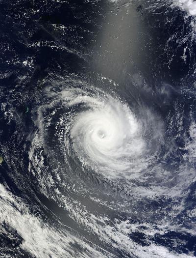
NASA's Terra satellite captured this visible image of Tropical
Cyclone Amara in the Southern Indian Ocean on Dec. 20 at 06:10 UTC.
(Photo Credit: Image : NASA Goddard MODIS Rapid Response Team)
(Photo Credit: Image : NASA Goddard MODIS Rapid Response Team)
Source: NASA/Goddard Space Flight Center

Amara : Rodrigues en alerte cyclonique de classe 3

"Vue sa position, son intensite et son movement, Amara devient un danger reel pour Rodrigues et en conséquence un avis de cyclone de Classe 3 est en vigueur a Rodrigues. On s'attend a ce que le temps a Rodrigues se détériore sensiblement a partir de cet apres-midi et la mer sera grosse", souligne la station météo de Vacoas à Maurice.
Le système dépressionnaire devant passer au plus près des côtes rodriguaises en début de soirée.
Nenhum comentário:
Postar um comentário