HOJE 22.12.2013 Ciclone Tropical Bruce
Ventos de 217 km/h e deslocamento no sentido sudoeste a 9 km/h.
21.12.2013 Ciclone Tropical Bruce
Ventos de 217 km/h e deslocamento no sentido oeste-sudoeste a 8 km/h CATEGORIA 5 NO OCEANO ÍNDICO.
20.12.2013 Ciclone Tropical Bruce
Ventos de 201 km/h e deslocamento no sentido oeste-sudoeste a 5 km/h, CATEGORIA 4.
19.12.2013 Ciclone Tropical Bruce
Ventos de 120 km/h e deslocamento no sentido oeste-sudoeste a 4 km/h NO OCEANO ÍNDICO categoria 1.
Ciclone Tropical Bruce
Ventos de 80 km/h e deslocamento no sentido sudoeste a 5 km/h NO OCEANO ÍNDICO.

ilone Tropical Bruce
reunion.la1ere.fr
Amara et Bruce respectivement à 1 040 et 3 545 kilomètres de La Réunion
- Par Erwann Ponnet
- Publié le 20/12/2013 | 10:23, mis à jour le 20/12/2013 | 11:06

© MTEOTEC
Les deux cyclones tropicaux Amara à 1090 km et Bruce à 3680 km de La Réunion
Météo France a baptisé un second système dans la nuit du jeudi 19 décembre au vendredi 20 décembre. Bruce est un cyclone tropical situé par 13.6 Sud et 88.4 Est, soit à 3 545 kilomètres de La Réunion. Le cyclone se déplace à 19 km/h à l'Ouest-Sud-Ouest. La pression au centre du système est de 935 Hpa. Évidemment, le cyclone Bruce est bien trop loin pour représenter la moindre menace pour La Réunion dans les prochains jours...
Plus proche de nous, Amara, premier système baptisé de la saison, est désormais à un millier de kilomètres des côtes réunionnaises. Le cyclone tropical poursuit sa course à 13 km/h au Sud-Ouest et menace toujours l'île Rodrigues. Selon les services météorologiques mauriciens, et " d'après les derniers images satellitaires l'Intense Cyclone Tropical "AMARA" a maintenu son intensité et sa force de frappe au cours de la nuit et s'approche de l'ile Rodrigues dangereusement...Amara devient un danger réel pour Rodrigues et conséquemment un avis de cyclone de Classe 3 est en vigueur à Rodrigues ".

antaranews.com
Cyclone Bruce strikes some Indonesia`s areas
Wed, December 18 2013 18:51 | 881 Views
The Bruce Cyclone that passes through Indonesia also has weather impacts in some regions, including light to moderate rain in western and southern Bengkulu, western and southern Lampung, Jakarta, and Banten.
The agency has warned that the impact of the Indian Ocean centered Cyclone Bruce will move to south and southwestern Indonesia or 970 kilometers of Bengkulu Province area at a maximum speed of 35 knots or 65 kilometers per hour on Wednesday.
BMKG has also predicted that on December 19, the cyclone will move away from Indonesia to the southwest or 1,260 kilometers of southwestern Bengkulu area, with a maximum speed of 55 knots or 100 kilometers per hour.
The agency has also predicted that for the next 48 hours, the speed will be 75 knots or 140 kilometers per hour, and will move away from Indonesia on December 20. The prediction for the next 72 hours states that the cyclone will move away with a maximum speed of 90 knots or 165 kilometers per hour.
The Bruce Cyclone that passes through Indonesia also has weather impacts in some regions, including light to moderate rain in western and southern Bengkulu, western and southern Lampung, Jakarta, and Banten.
Besides, Cyclone Bruce has impacted a 3-4 meters sea waves rise in Nias Islands, western Padang, western Lampung and the Indian Ocean near Banten coastal areas, as also 4-6 meters sea waves rise in Mentawai Islands, Enggano coastal area of Bengkulu, and West Indian Ocean along the Mentawai Island and the Lampung Province.
Meanwhile, hurricanes with speed of more than 20 knots will potentially strike west coastal Sumatra from the central to southern areas. (*)
sciencecodex.com
NASA sees powerful Tropical Cyclone Bruce staying away from land
Posted By News On December 20, 2013 - 8:00pm
Tropical
Cyclone Bruce continued to strengthen over wide open waters of the
Southern Indian Ocean and NASA satellite data showed its eye had cleared
of clouds. Bruce is forecast to stay away from land areas and weaken
over the next four days.
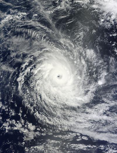
The Moderate Resolution Imaging Spectroradiometer or MODIS instrument that flies aboard NASA's Terra satellite captured a visible image of a more wide-eyed Tropical Cyclone Bruce on Dec. 20 at 04:30 UTC. In the satellite image, the ocean surface was visible in the center of Bruce's 25 nautical-mile/28.7 mile/46.3 km-wide eye.
As of 1500 UTC/10 a.m. EST on Dec. 20, Bruce had rapidly intensified by 35 knots/40.2 mph/64.8 kph over the previous 24 hours and an astonishing 70 knots/80 mph/129.6 kph over the previous 48 hours.

Tropical cyclone Bruce had maximum sustained winds near 125
knots/143.8 mph/231.5 kph on Dec. 20 at 1500 UTC/10 a.m. EST. That makes
Bruce equivalent to a Category 4 hurricane on the Saffir-Simpson Scale.
Bruce was creating very rough seas, generating waves as high as 30
feet/9.1 meters. Bruce was centered about 505 nautical miles/581.1
miles/935.3 km west-southwest of Cocos Island, Australia near 13.8
south latitude and 87.5 east longitude. Bruce is moving to the
west-southwest at 9 knots/10.3 mph/16.6 kph.
Forecasters at the Joint Typhoon Warning Center described Bruce's structure from animated multispectral satellite imagery as a "classic tropical cyclone structure with a deeply convective, symmetric eyewall surrounded by spiraling feeder bands in all quadrants."
In two days an approaching mid-latitude shortwave trough (elongated area) of low pressure moving in from the southwest will cause Bruce to curve to the southeast. The Joint Typhoon Warning Center expects Bruce to become extra-tropical after three of four days.
The Moderate Resolution Imaging Spectroradiometer or MODIS instrument that flies aboard NASA's Terra satellite captured a visible image of a more wide-eyed Tropical Cyclone Bruce on Dec. 20 at 04:30 UTC. In the satellite image, the ocean surface was visible in the center of Bruce's 25 nautical-mile/28.7 mile/46.3 km-wide eye.
As of 1500 UTC/10 a.m. EST on Dec. 20, Bruce had rapidly intensified by 35 knots/40.2 mph/64.8 kph over the previous 24 hours and an astonishing 70 knots/80 mph/129.6 kph over the previous 48 hours.

NASA's Terra satellite captured this visible image of Tropical
Cyclone Bruce in the Southern Indian Ocean on Dec. 20 at 04:30 UTC.
(Photo Credit: Image : NASA Goddard MODIS Rapid Response)
(Photo Credit: Image : NASA Goddard MODIS Rapid Response)
Forecasters at the Joint Typhoon Warning Center described Bruce's structure from animated multispectral satellite imagery as a "classic tropical cyclone structure with a deeply convective, symmetric eyewall surrounded by spiraling feeder bands in all quadrants."
In two days an approaching mid-latitude shortwave trough (elongated area) of low pressure moving in from the southwest will cause Bruce to curve to the southeast. The Joint Typhoon Warning Center expects Bruce to become extra-tropical after three of four days.
Source: NASA/Goddard Space Flight Center

Nenhum comentário:
Postar um comentário