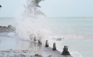
 TEMPORADA DE CICLONES NO OCEANO ÍNDICO
IMAGENS EM TEMPO REAL
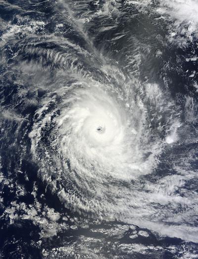
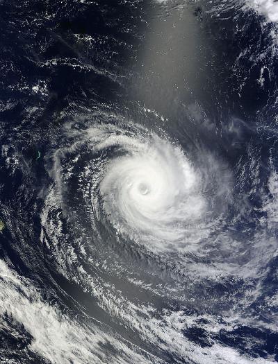
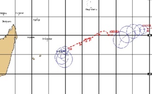
HOJE, 22.12.2013 Ciclone Tropical Amara
Ventos de 193 km/h e deslocamento no sentido este-sudeste a 6 km/h CATEGORIA 3.
21.12.2013 Ciclone Tropical Amara
Ventos de 209 km/h e deslocamento no sentido sul-sudeste a 3 km/h CATEGORIA 4.
20.12.2013 Ciclone Tropical Amara
Ventos de 176 km/h e deslocamento no sentido oeste-sudoeste a 3 km/h, CATEGORIA 3.
19.12.2013 Ciclone Tropical Amara
Ventos de 168 km/h e deslocamento no sentido oeste-sudoeste a 5 km/h EM DIREÇÃO ÀS ILHAS REUNIÃO, CATEGORIA 2.
18.12.2013 Ciclone Tropical Amara
Ventos de 128 km/h e deslocamento no sentido oeste a 1 km/h em direção às ilhas Reunião e Madagascar Categoria 1.
Em 17.12.2013 Ciclone Tropical Amara, com ventos de 56 km/h e deslocamento no sentido noroeste a 0 km/h EM DIREÇÃO À MADAGASCAR.


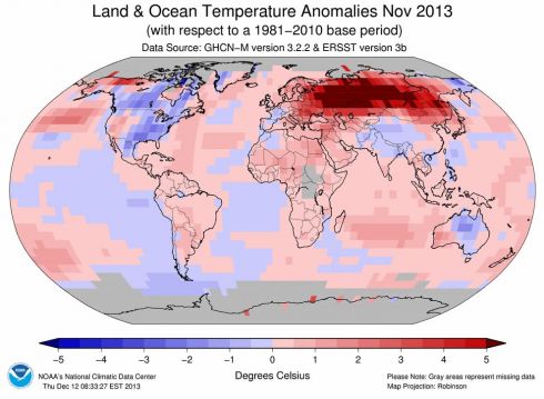
 Temperaratura do mar perto das ilhas Reunião chegar a estar até 4°C acima do normal.


 Samedi 21 Décembre 2013 - 13:08
Rodrigues : Le passage du cyclone Amara provoque "des dégâts considérables"

Le cyclone tropical intense Amara s'éloigne à présent peu à peu de
l'île Rodrigues. Selon la station météorologique de Vacoas, basée à
Maurice, Amara se situait à 10h ce matin à une distance de 70km au
Sud-Est de Rodrigues.
Amara étant toujours à proximité de l'île, l'avertissement de cyclone de classe 4 est maintenu dans l'île.
Des rafales ont été enregistrées à 121 km/h du côté de Pointe Canon, à
100 km/h à Plaine Corail et à 108 km/h à Citronelle. La pluie continue
de s'abattre sur lîle et la météo mauricienne signale toujours une mer "phénoménale accompagnée de raz de marée et d'inondations côtières".
On en sait par ailleurs un peu plus sur les dégâts causés par le passage du cyclone dans la petite île. L'Express de Maurice souligne que "les dégâts sont considérables",
ajoutant que des feuilles de tôle ont été emportées par les fortes
rafales, des pylones électriques se retrouvent à terre et que des
radiers sont submergés. "L'électricité a été coupée dans l'île", ajoutent nos confères de l'Express de Maurice.
Tous les vols en provenance et à destination de Rodrigues sont par ailleurs annulés jusqu'à nouvel ordre.
Samedi 21 Décembre 2013 - 13:08
reunion.la1ere.fr
Le cyclone Amara est 1645 km de La Réunion
- Par Erwann Ponnet
- Publié le 18/12/2013 | 16:57, mis à jour le 18/12/2013 | 16:57
A 16 heures, le cyclone tropical Amara se trouve à 1645
kilomètres à l'Est Nord Est de La Réunion et se déplace à
l'Ouest-Sud-ouest à 6 km/h.
Selon le dernier bulletin de Météo France, Amara se trouve ce
mercredi à 16 heures à 1645 km à l'est-Nord-Est de La Réunion. Le
système dépressionnaire devenu cyclone tropical se déplace à
l'Ouest-Sud-Ouest à 6 km/h. La pression au centre du cyclone est de 970
Hpa.
Amara est très exactement situé par 16.3 Sud et 70.6 Est et Météo France
prévoit un passage au stade de cyclone tropicale intense dans les 24
prochaines heures.
voici les intensités et les positions prévues de ce système dépressionnaire au cours des prochains jours :
- cyclone tropicale intense, centre positionné, à 16 heures, le jeudi 19 décembre par 16.8 S et 67.7 E
- cyclone tropicale intense, centre positionné, à 16 heures, le vendredi 20 décembre par 17.9 S et 64.6 E
- cyclone tropicale intense, centre positionné, à 16 heures, le samedi 21 décembre par 19.3 S et 63.3 E
- cyclone tropicale, centre positionné, à 16 heures, le dimanche 22 décembre par 20.4 S et 63.7 E
- tempête tropicale modérée, centre positionné, à 16 heures, le lundi 23 décembre par 21.3 S et 64.0 E
Météo
France rappelle que ces prévisions de trajectoires et d'intensité sont à
considérer avec la plus grande prudence compte tenu de leur
incertitude.
December 17, 2013
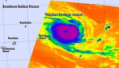
Image Caption: NASA's TRMM satellite captured this image of
rainfall rates occurring in Tropical Cyclone Amara on Dec. 17 at 05:52
UTC/12:52 a.m. EST, and heavy rain (red) was happening in the center and
northwestern quadrants. Credit: NASA/SSAI, Hal Pierce
NASA/Goddard Space Flight Center
System 93S strengthened into the third tropical depression of the
Southern Indian Ocean cyclone season, which quickly became a tropical
storm named Amara. NASA’s TRMM and Aqua satellites flew overhead shortly
after formation and provided visible and rainfall data on the
intensifying storm.
Amara’s maximum sustained winds were near 35 knots/40 mph/62 kph on
December 17 at 0900 UTC/4 a.m. EST. Amara was located near 15.6 south
latitude and 72.0 east longitude, about 500 nautical miles/575.4
miles/926 km south of Diego Garcia. Amara is crawling to the northwest
at 1 knot/1.1 mph/1.8 kph, because it is moving between two sub-tropical
ridges (elongated areas) of high pressure. The storm’s course is
forecast to change, however, as a new steering influence comes into
play.
NASA’s Tropical Rainfall Measuring Mission or TRMM satellite captured
data on rainfall rates occurring in Tropical Cyclone Amara on Dec. 17
at 05:52 UTC/12:52 a.m. EST. TRMM saw heavy rain occurring around the
center and northwestern quadrant of the tropical storm. Rainfall rates
in those areas topped 50 mm/2 inches per hour.
Over two hours later, NASA’s Aqua satellite passed over the storm
from its orbit in space. The Moderate Resolution Imaging
Spectroradiometer or MODIS instrument captured a visible image of
newborn Tropical Cyclone Amara at 08:20 UTC/3:20 a.m. EST that revealed
the storm had good circulation.
Forecasters at the Joint Typhoon Warning Center or JTWC noted that
the banding structure of thunderstorms around the system remains tightly
curved, while the 35-knot/40 mph/62 kph winds are concentrated in the
northeast quadrant.
In four days, by December 21, a strong mid-latitude trough, or
elongated area of low pressure is expected to pass south of the cyclone
and slow it down and cause it to dip toward the southwest. The Joint
Typhoon Warning Center expects that Tropical Cyclone Amara will continue
to strengthen over the next 5 days reaching hurricane-strength by
December 22 as it nears La Reunion Island. Residents of La Reunion
Island should closely monitor the progress of Tropical Cyclone Amara.
Read more at http://www.redorbit.com/news/space/1113030135/tropical-cyclone-amara-gets-double-coverage-from-nasa-121713/#flfEPQPDp3mAQUhr.
Newborn Tropical Cyclone Amara Gets Double Coverage From NASA
December 17, 2013
Image Caption: NASA's TRMM satellite captured this image of
rainfall rates occurring in Tropical Cyclone Amara on Dec. 17 at 05:52
UTC/12:52 a.m. EST, and heavy rain (red) was happening in the center and
northwestern quadrants. Credit: NASA/SSAI, Hal Pierce
NASA/Goddard Space Flight Center
System 93S strengthened into the third tropical depression of the
Southern Indian Ocean cyclone season, which quickly became a tropical
storm named Amara. NASA’s TRMM and Aqua satellites flew overhead shortly
after formation and provided visible and rainfall data on the
intensifying storm.
Amara’s maximum sustained winds were near 35 knots/40 mph/62 kph on
December 17 at 0900 UTC/4 a.m. EST. Amara was located near 15.6 south
latitude and 72.0 east longitude, about 500 nautical miles/575.4
miles/926 km south of Diego Garcia. Amara is crawling to the northwest
at 1 knot/1.1 mph/1.8 kph, because it is moving between two sub-tropical
ridges (elongated areas) of high pressure. The storm’s course is
forecast to change, however, as a new steering influence comes into
play.
NASA’s Tropical Rainfall Measuring Mission or TRMM satellite captured
data on rainfall rates occurring in Tropical Cyclone Amara on Dec. 17
at 05:52 UTC/12:52 a.m. EST. TRMM saw heavy rain occurring around the
center and northwestern quadrant of the tropical storm. Rainfall rates
in those areas topped 50 mm/2 inches per hour.
Over two hours later, NASA’s Aqua satellite passed over the storm
from its orbit in space. The Moderate Resolution Imaging
Spectroradiometer or MODIS instrument captured a visible image of
newborn Tropical Cyclone Amara at 08:20 UTC/3:20 a.m. EST that revealed
the storm had good circulation.
Forecasters at the Joint Typhoon Warning Center or JTWC noted that
the banding structure of thunderstorms around the system remains tightly
curved, while the 35-knot/40 mph/62 kph winds are concentrated in the
northeast quadrant.
In four days, by December 21, a strong mid-latitude trough, or
elongated area of low pressure is expected to pass south of the cyclone
and slow it down and cause it to dip toward the southwest. The Joint
Typhoon Warning Center expects that Tropical Cyclone Amara will continue
to strengthen over the next 5 days reaching hurricane-strength by
December 22 as it nears La Reunion Island. Residents of La Reunion
Island should closely monitor the progress of Tropical Cyclone Amara.
Read more at http://www.redorbit.com/news/space/1113030135/tropical-cyclone-amara-gets-double-coverage-from-nasa-121713/#flfEPQPDp3mAQUhr.99
Newborn Tropical Cyclone Amara Gets Double Coverage From NASA

Image
Caption: NASA's TRMM satellite captured this image of rainfall rates
occurring in Tropical Cyclone Amara on Dec. 17 at 05:52 UTC/12:52 a.m.
EST, and heavy rain (red) was happening in the center and northwestern
quadrants. Credit: NASA/SSAI, Hal Pierce
NASA/Goddard Space Flight Center
System 93S strengthened into the third tropical depression of the
Southern Indian Ocean cyclone season, which quickly became a tropical
storm named Amara. NASA’s TRMM and Aqua satellites flew overhead shortly
after formation and provided visible and rainfall data on the
intensifying storm.
Amara’s maximum sustained winds were near 35 knots/40 mph/62 kph on
December 17 at 0900 UTC/4 a.m. EST. Amara was located near 15.6 south
latitude and 72.0 east longitude, about 500 nautical miles/575.4
miles/926 km south of Diego Garcia. Amara is crawling to the northwest
at 1 knot/1.1 mph/1.8 kph, because it is moving between two sub-tropical
ridges (elongated areas) of high pressure. The storm’s course is
forecast to change, however, as a new steering influence comes into
play.
NASA’s Tropical Rainfall Measuring Mission or TRMM satellite captured
data on rainfall rates occurring in Tropical Cyclone Amara on Dec. 17
at 05:52 UTC/12:52 a.m. EST. TRMM saw heavy rain occurring around the
center and northwestern quadrant of the tropical storm. Rainfall rates
in those areas topped 50 mm/2 inches per hour.
Over two hours later, NASA’s Aqua satellite passed over the storm
from its orbit in space. The Moderate Resolution Imaging
Spectroradiometer or MODIS instrument captured a visible image of
newborn Tropical Cyclone Amara at 08:20 UTC/3:20 a.m. EST that revealed
the storm had good circulation.
Forecasters at the Joint Typhoon Warning Center or JTWC noted that
the banding structure of thunderstorms around the system remains tightly
curved, while the 35-knot/40 mph/62 kph winds are concentrated in the
northeast quadrant.
In four days, by December 21, a strong mid-latitude trough, or
elongated area of low pressure is expected to pass south of the cyclone
and slow it down and cause it to dip toward the southwest. The Joint
Typhoon Warning Center expects that Tropical Cyclone Amara will continue
to strengthen over the next 5 days reaching hurricane-strength by
December 22 as it nears La Reunion Island. Residents of La Reunion
Island should closely monitor the progress of Tropical Cyclone Amara.
Read more at
http://www.redorbit.com/news/space/1113030135/tropical-cyclone-amara-gets-double-coverage-from-nasa-121713/#flfEPQPDp3mAQUhr.99
Image
Caption: NASA's TRMM satellite captured this image of rainfall rates
occurring in Tropical Cyclone Amara on Dec. 17 at 05:52 UTC/12:52 a.m.
EST, and heavy rain (red) was happening in the center and northwestern
quadrants. Credit: NASA/SSAI, Hal Pierce
NASA/Goddard Space Flight CenterSystem 93S strengthened into the third tropical depression of the
Southern Indian Ocean cyclone season, which quickly became a tropical
storm named Amara. NASA’s TRMM and Aqua satellites flew overhead shortly
after formation and provided visible and rainfall data on the
intensifying storm.Amara’s maximum sustained winds were near 35 knots/40 mph/62 kph on
December 17 at 0900 UTC/4 a.m. EST. Amara was located near 15.6 south
latitude and 72.0 east longitude, about 500 nautical miles/575.4
miles/926 km south of Diego Garcia. Amara is crawling to the northwest
at 1 knot/1.1 mph/1.8 kph, because it is moving between two sub-tropical
ridges (elongated areas) of high pressure. The storm’s course is
forecast to change, however, as a new steering influence comes into
play.NASA’s Tropical Rainfall Measuring Mission or TRMM satellite captured
data on rainfall rates occurring in Tropical Cyclone Amara on Dec. 17
at 05:52 UTC/12:52 a.m. EST. TRMM saw heavy rain occurring around the
center and northwestern quadrant of the tropical storm. Rainfall rates
in those areas topped 50 mm/2 inches per hour.Over two hours later, NASA’s Aqua satellite passed over the storm
from its orbit in space. The Moderate Resolution Imaging
Spectroradiometer or MODIS instrument captured a visible image of
newborn Tropical Cyclone Amara at 08:20 UTC/3:20 a.m. EST that revealed
the storm had good circulation.Forecasters at the Joint Typhoon Warning Center or JTWC noted that
the banding structure of thunderstorms around the system remains tightly
curved, while the 35-knot/40 mph/62 kph winds are concentrated in the
northeast quadrant.In four days, by December 21, a strong mid-latitude trough, or
elongated area of low pressure is expected to pass south of the cyclone
and slow it down and cause it to dip toward the southwest. The Joint
Typhoon Warning Center expects that Tropical Cyclone Amara will continue
to strengthen over the next 5 days reaching hurricane-strength by
December 22 as it nears La Reunion Island. Residents of La Reunion
Island should closely monitor the progress of Tropical Cyclone Amara.

Le cyclone Amara poursuit sa trajectoire vers Rodrigues
Publié : mercredi 18 décembre 2013 à 22:56
- Modifié : 18/12/2013 à 09:40
Situé ce mercredi soir à 1540 km à l’est-nord-est
de La Réunion, le cyclone tropical Amara poursuit sa trajectoire vers
l’île de Rodrigues. Il se déplace actuellement à 11 km/h en direction de
l’ouest-sud-ouest.
Selon le dernier point de Météo France diffusé ce mercredi à 22h30, le
cyclone Amara accélère légèrement puisqu’il se déplacement à 11 km/h en direction de l’ouest-sud-ouest. Ce météore
menace toujours Rodrigues et l’alerte 1 pourrait donc être déclenchée sur cette île dès demain.
Le premier cyclone de la saison cyclonique 2013-2014 est
actuellement positionné par 16.9 SUD / 69.8 EST à 1540 km à
l’est-nord-est de
La Réunion. La pression estimée au centre d’Amara est de 966 HPA.
Amara : Rodrigues pourrait passer en alerte 2
Publié : jeudi 19 décembre 2013 à 16:23
A
l’approche du cyclone tropical intense Amara, l’archipel de Rodrigues
pourrait être placé en alerte 2 avant la fin de cette journée.
Déclenchée depuis ce matin, l’alerte 1 reste en vigueur.
Première cible du cyclone tropical
intense Amara, l’archipel de Rodrigues pourrait passer en alerte
cyclonique 2 dès cet après-midi. "Le cyclone tropical intense Amara s’est encore rapproché de Rodrigues dans la journée. Des vents très forts sont attendus", annonce la station météorologique de Vacoas à l’île Maurice.
En attendant que le niveau d’alerte
ne monte d’un cran, l’avertissement de cyclone de classe 1, activé ce
matin, est maintenu en vigueur.
Selon Météo Maurice, le cyclone
tropical intense Amara continue de foncer vers Rodrigues et se situe à
environ 570 km de ses côtes. Après avoir déclenché l’alerte 1 ce jeudi
19 décembre, dans la matinée, "On écarte pas la possibilité de passer en alerte 2 en fin d’après-midi", prévient la station météorologique de Vacoas.
Le météore poursuit sa course vers l’ouest-sud-ouest à une vitesse de 10 km/h. "Vu sa position et sa trajectoire, il représente un danger pour Rodrigues", estime le prévisionniste mauricien Prem Pathak, dans des propos relayés par L’Express de Maurice.
Le temps se dégrade peu à peu à Rodrigues, en proie à un épisode venteux, nuageux et pluvieux. "Il y a des vents très forts au centre" avec parfois des rafales de 230 km/h. Dès demain, de grosses pluies sont attendues.
theepochtimes.com
Tropical Cyclone Amara Beings Heavy Rain and is Forecasted to Strengthen
Tropical Cyclone Amara is headed toward the
Mauritius’ Rodrigues Island, prompting warnings, and weather forecasters
say the storm is expected to strengthen.
The storm has hurricane-strength winds as of December 19, at about
120 miles per hour, NASA said. The winds have been combined with heavy
rain.
Amara, currently in the middle of the Indian Ocean, has the Republic
of Mauritius on alert. The Rodrigues Island is expected to get hit, as
well as other islands,
reported Afrique Jet.
“The Mauritian Meteorological services have indicated that Amara
represents a potential danger for Rodrigues island, given its current
position as well as its trajectory,” it reported.
By December 21, the storm is forecasted to turn to the southwest.
“The Joint Typhoon Warning Center expects that Tropical Cyclone Amara
will continue to strengthen over the next 5 days reaching
hurricane-strength by December 22 as it nears La Reunion Island,” NASA
said on December 16. “Residents of La Reunion Island should closely
monitor the progress of Tropical Cyclone Amara.”
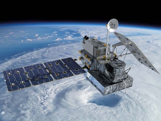 Concepção artística mostra o satélite GPM no espaço (Foto: NASA's Goddard Space Flight Center)


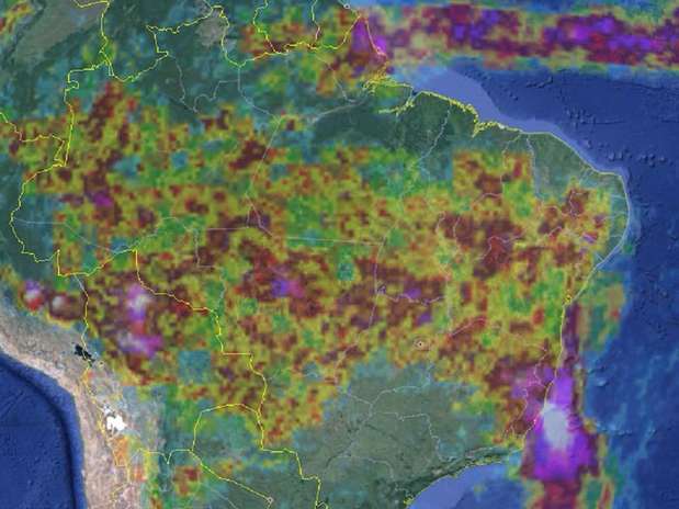




 Reservatório de água cheio após as chuvas (Foto: Maria Lima/G1 Petrolina)
 Motorista encontra dificuldade para passar por
 Metereologista Mário de Miranda prevê chuvas para
 O verde reaparece em meio à caatinga


