

IMAGEM ANIMADA DO DIA 10.02.2015
do tufão Higos no Pacífico Oeste, próximo às Ilhas Marianas na Micronésia, CATEGORIA 3.


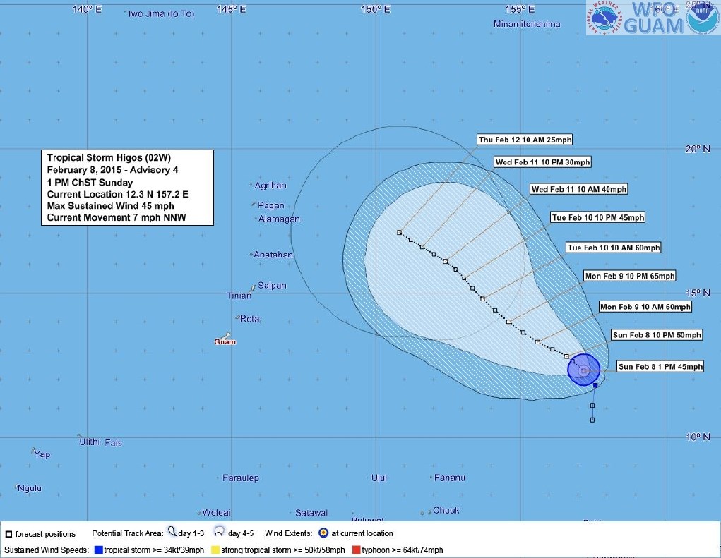
TUFÃO HIGOS DIA 08.02.2015 CATEGORIA 1
imagem visivel

| Last Updated | 10/02/2015, 04:00:00 (Hora oficial do Brasil) | ||
| Location | 14.2N 205.8E | Movement | NW at 8 mph |
| Wind | 195KPH CATEGORIA 3 | ||
| Last Updated | 09/02/2015, 04:00:00 (Hora oficial do Brasil) | ||
| Location | 12.5N 203.9E | Movement | NW at 4 mph |
| Wind | 150KPH | ||
| Last Updated | 08/02/2015, 16:00:00 (Hora oficial do Brasil) | ||
| Location | 12.2N 203.3E | Movement | WNW at 3 mph |
| Wind | 120KPH CATEGORIA 1 | ||
| Last Updated | 08/02/2015, 10:00:00 (Hora oficial do Brasil) | ||
| Location | 12.2N 203.2E | Movement | WSW at 4 mph |
| Wind | 100KPH | ||


pacificnewscenter.com
Typhoon Higos
Written by Joanna Oh
Higos will keep well east of the Marianas this week.
Guam - Once tropical storm Higos is now a typhoon,
according to the public advisory released this morning from the National
Weather Service.
NWS explains in details that "A slow west-northwest to
northwest motion is expected through Thursday, curving more to the north
Friday and Saturday. This forecast track would keep typhoon Higos well
east of the Marianas through the week."
According to the NWS forecast, Higos is expected to slowly
weaken starting Tuesday, and to eventually drop its status down to
weakening tropical depression about 500 miles north east of Saipan by
Saturday.
As of current, NWS issued both high surf and small craft
advisories due to the high surf and seas caused by Higos, and indicated
in the public advisory that more update will be issued today 2 PM.
READ THE LATEST WEATHER FORECAST FROM NWS
.TODAY...PARTLY SUNNY WITH ISOLATED SHOWERS. NORTHEAST WINDS 15 TO 20 MPH. HIGHS AROUND 88.
.TONIGHT THROUGH WEDNESDAY NIGHT...MOSTLY CLOUDY WITH ISOLATED SHOWERS. NORTHEAST WINDS 10 TO 20 MPH. LOWS NEAR 77. HIGHS
AROUND 88.
AROUND 88.
Published in
Weather
guampdn.com
Tropical Storm Higos to bring isolated showers, rip currents
A tropical storm just east of the Mariana Islands is expected to bring isolated showers and rip currents to Guam today through Tuesday, according to the National Weather Service.
The center of Tropical Storm Higos is about 840 miles east of Guam and 795 miles east-southeast of Saipan and is slowly drifting northwestward at 7 mph, an advisory from the weather service states.Maximum sustained winds have increased to 45 mph and the storm is anticipated to slowly intensify through Monday night and weaken on Tuesday when it is about 380 miles east-northeast of Saipan if it continues to stay on the northwest path, NWS Meteorologist Patrick Chan said.
The storm will not produce any major impact on the Mariana Islands, he said, but Guam and Saipan can expect isolated showers.
"(Residents) should not be concerned or panicked, but they should keep up-to-date on what's going on," he said.
The storm will also bring trade winds at speeds of 15 to 24 mph in the daytime and 12 to 20 mph at night, Chan said.
He added there is a moderate risk of rip currents on the island’s north- and east-facing shores.
“If they stay inside the reef, they’ll be OK. If they go outside the reef, it’s dangerous,” Chan said.
Rip currents might also occur closer to the shores, Chan said.
“Chances are a little bit high, so just be aware of that,” he said.

Nenhum comentário:
Postar um comentário