


01.04.2014 Caiu para Tropical Depressão Hellen ventos de 40km/h.
31.03.2014 Ciclone Tropical Hellen, com ventos de 201 km/h e deslocamento no sentido este-sudeste a 3 km/h em Madagascar.
30.03.2014 Ciclone Tropical Hellen, com ventos de 209 km/h e deslocamento no sentido sudeste a 2 km/h EM MADAGASCAR.
30.03.2014 Ciclone Tropical Hellen, com ventos de 144 km/h e deslocamento no sentido sudeste a 4 km/h em MADAGASCAR.
29.03.2014 Ciclone Tropical Hellen, com ventos de 72 km/h e deslocamento no sentido sudeste a 1 km/h EM MADAGASCAR.
Trajetória final do Ciclone Tropical Hellen
Imagem do dia 31.03.2014 mostra Ciclone Tropical Hellen em dissipação.

LOCALIZAÇÃO


Météo : Hellen s’affaiblit sur Madagascar
Pas facile d’avoir des informations sur le passage de l’ex-Hellen sur les terres malgaches.
Un moindre mal avec de fortes pluies et des vents violents, le météore s’étant considérablement affaibli avec son passage sur terre. Elle ne provoque plus que des rafales de vent atteignant les 50 km/h.
A 15 heures locales, son centre se trouvait à 80 km au centre de Besalampy selon le bulletin du Bureau national de gestion des risques et des catastrophes. Elle se déplace vers le Sud Ouest et ne devrait pas tarder à ressortir en mer.
A Madagascar, on reste en alerte car les résidus peuvent encore apporter de la pluie qui pourrait entraîner la montée des eaux et des glissements de terrain.
Sur l’ensemble des districts impactés, un premier bilan fait état de 1 004 sinistrés, 919 sans abris, 176 cases détruites, 97 cases inondées, 1 bâtiment administratif décoiffé, 1 Ecole Primaire Publique (EPP) décoiffée, 1 EPP endommagée, 3 962 ha de rizières inondées, 112 ha de champs de cultures inondés, 6 poteaux de la Jirama (l’équivalent d’EDF) endommagés, 1 barrage endommagé, 10 pirogues disparues.
Les réseaux d’eau et d’électricité de la Jirama , à Mahajanga I et à Mitsinjo, sont désormais à nouveau fonctionnels. Le niveau des eaux commence à baisser dans la ville de Mahajanga.
Rien de bien grave compte tenu des situations précaires des Malgaches.
La vie avait repris son cours ce matin à Majunga.
 01/04
: Le cyclone "Hellen", entré sur terre au stade de cyclone tropical
intense du côté du district de Mitsinjo (au nord-ouest de la grande île)
, est sortie en mer ce matin, a indiqué le bureau national de gestion
des risques et des catastrophes (BNGRC) dans son bulletin
météorologique.
01/04
: Le cyclone "Hellen", entré sur terre au stade de cyclone tropical
intense du côté du district de Mitsinjo (au nord-ouest de la grande île)
, est sortie en mer ce matin, a indiqué le bureau national de gestion
des risques et des catastrophes (BNGRC) dans son bulletin
météorologique.A Majunga, une ville portuaire du nord-ouest de l’île, les rafales de vent d’une vitesse inouïe de plus de 250km/h ont projeté les énormes blocs de pierres qui longeaient les bords de mer hors des digues.
Le BNGRC a recensé jusqu'ici 237 sinistrés qui sont tous sans abris et 51 cases d'habitations inondées. Une montée des eaux a été signalée dans quelques quartiers de Majunga (à l'ouest).
Trois pêcheurs sont morts noyés et 11 autres portés disparus à la suite du naufrage d’une vedette t à proximité de l’île Makamby.
http://earthsky.org
Mar 31, 2014
Tropical Cyclone Hellen crushing parts of Madagascar
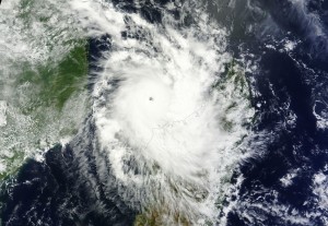
Cyclone Hellen on Mar. 29, 2014 via NASA
|
|
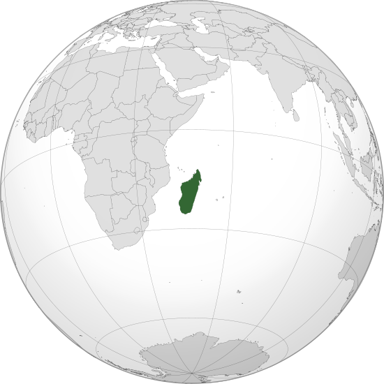
Location of Madagascar in the Indian Ocean. Image via Wikipedia
In the Indian Ocean, tropical cyclone season typically begins in November and ends in April every year. On average, 12.5 cyclones typically form in the Indian Ocean each year. As of 6 a.m. EDT ((10 UTC) on March 31, Hellen is roughly 240 nautical miles north-northwest of Antananarivo, Madagascar. Sustained winds are roughly around 100 to 120 knots, or approximately a Category 3 or 4 storm with sustained winds around 115-140 mph. Dry air has entered into the core of the cyclone, and a weakening trend is being detected through satellite. Although it will not hit as a Category 4 storm, it will still be formidable storm capable of producing significant damage. The strong winds from the storm will create a dangerous storm surge along the northwest coast of Madagascar as it pushes to the southeast. Since areas of low pressure spin clockwise in the Southern Hemisphere, winds and storm surge will be pushing onshore into Mahajanga, Boanamary, and even into Antonibe. Landfall has occurred across Mahajanga, Madagascar this morning. Mahajanga has a population of roughly 150,000 people. An area of high pressure nearby will slow the storm down which will enhance the rainfall in the region. The forecast track is for the storm to eventually push to the southwest and possibly make a second landfall somewhere across Mozambique. Of course, if the storm pushes further inland in Madagascar and encounters even more dry air, it could dissipate before making a turn towards Mozambique.
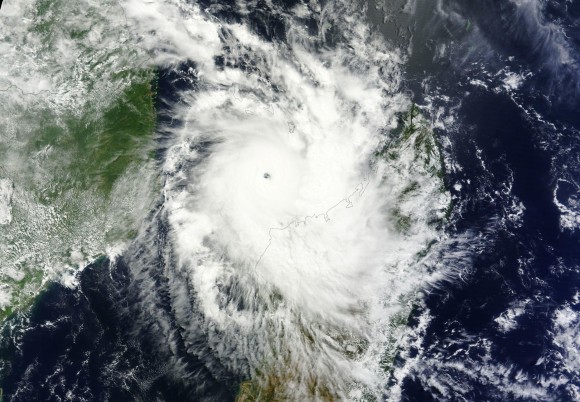
Cyclone Hellen as an intense Category 4 storm off the coast of Madagascar on March 29, 2014. Image via NASA
“HELLEN IS LIKELY TO BE ONE OF THE MOST POWERFUL TROPICAL CYCLONES EVER SEEN OVER THE NORTHERN CHANNEL SINCE THE SATELLITE ERA (1967)”
THE INHABITANTS OF THE NORTH-WESTERN COASTS OF MADAGASCAR EMBRACED FOR AN EXTREMELY DANGEROUS TROPICAL CYCLONE. ALL PREPARATIONS FOR A “WORST CASE” SCENARIO SHOULD BE UNDERWAY AS A LANDFALLING INTENSE SYSTEM BETWEEN CAPE SAINT-ANDRE AND MAHAJONGA IS STILL CLEARLY A POSSIBILITY.
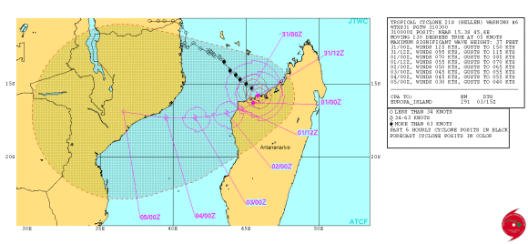
Tropical Cyclone Hellen forecast track. Image via Joint Typhoon Warning Center
La meilleure info météo
Cyclone Hellen : l'île de Mayotte en alerte cyclonique Orange
Actualités - Publiée le dimanche 30 mars 2014 par La Chaîne Météo
Née jeudi au sud des îles Comores, une dépression tropicale s'est rapidement renforcée et a été baptisée "Hellen". La trajectoire de cette tempête, entre-temps devenue cyclone la nuit passée, constitue une très importante menace pour l'île Mayotte et le nord de l'île de Madagascar. L'île de Mayotte est d'ailleurs placée en alerte...
Née jeudi au sud des îles Comores, une dépression tropicale s'est rapidement renforcée et a été baptisée "Hellen".
La trajectoire de cette tempête, entre-temps devenue cyclone la nuit
passée, constitue une très importante menace pour l'île Mayotte et le
nord de l'île de Madagascar.
L'île de Mayotte est d'ailleurs placée en alerte cyclonique "Orange" pour les 36 prochaines heures. Ce cyclone était situé dimanche matin à environ 200 km au sud-ouest de l'île.
Ce cyclone continue à se renforcer très rapidement et pourrait même atteindre le niveau de cyclone de catégorie 4/5, avec des rafales approchant les 250 km/h près de son oeil demain lundi. Ce cyclone induit une forte houle sur l'île de Mayotte avec des creux de 4 à 7 mètres sur le sud de l'île, et des pluies marquées dimanche et lundi avec des cumuls pouvant atteindre les 300mm en 24 d'ici lundi après-midi.
On relève entre samedi et dimanche 6h
*239 mm à M'Tsamboro
*195 mm à Poroani
*181 mm à Vahibé
*153 mm à Dembeni
*106 mm à Pamandzi
Ces fortes pluies sont à l'origine de crues sur le centre de l'île, d'inondations localisées parfois spectaculaires.
Par la suite, ce cyclone incurvera sa course vers le Sud-est, s'approchant cette fois des côtes nord de Madagascar où des pluies diluviennes sont attendues en milieu de semaine. Par la suite, sa trajectoire n'est pas encore bien définie. Hellen pourrait infléchir sa course vers le Sud-ouest et venir se positionner au centre du canal de Mozambique, avant de baisser en intensité...

Ciclone Tropicale Hellen: allerta per il Madagascar
Ciclone Tropicale Hellen sale a categoria 4, in allerta il Madagascar.
Ciclone Tropicale Hellen- nata come depressione nella giornata di Giovedì a Sud delle Isole Comore, Hellen si è rapidamente evoluta in Ciclone Tropicale transitando sulle calde acque dell’Oceano Indiano, raggiungendo in queste ore categoria 4 sulla scala Saffir -Simpson. Allerta massima per l’Isola di Mayotte, posizionata a Nord del Canale di Mozambico, dove i venti potranno superare i 200 Km/h nelle prossime ore e le precipitazioni raggiungere i 150 mm in poche ore.
Ciclone Tropicale Hellen ; fonte immagine http://www.nrlmry.navy.mil/
In seguito, dopo aver portato condizioni di estremo maltempo nel Madagascar, il Ciclone Hellen scivolerà verso Sudovest, andando verso il Mozambico meridionale, seppur in costante indebolimento fino a declassare a tempesta tropicale.
Tropical Cyclone Hellen Approaches Madagascar

Hellen started as a disorganized area of showers and thunderstorms over the eastern third of Mozambique earlier this week, but recently entered an environment favorable for tropical development once it formed a low-level center of circulation and progressed over open water.
The cyclone is expected to strengthen over the Mozambique Channel as it continues slowly southeastward through the next 24-48 hours, progressing just south of the islands of Comorros and Mayotte before clipping the west coast of Madagascar late Sunday night EDT. The storm is currently expected to reach maximum strength of 80 mph, equivalent to category one hurricane strength in the Western Hemisphere, over open water early Sunday morning EDT.
The center of the storm is expected to stay over water, as a ridge of high pressure building over Madagascar forces most of the storm to stay over the Mozambique Channel. This ridge will force Hellen in a more westerly direction starting Sunday night or Monday. The interaction with land and the drier air associated with the high pressure area should act to weaken the system before it reaches the coast of Mozambique toward the middle of next week.
Even if Hellen does not make landfall, it may still bring heavy rain and gusty winds to the northwest portion of Madagascar Saturday night and Sunday that can result in flooding and mudslides, along with downed trees and power lines.
Updated by AccuWeather.com Meteorologist Alan Reppert
Nenhum comentário:
Postar um comentário